03/10
- 06/10/00
back to homepage / zurück
zur Homepage
03.10.00 Drive to Petroglyph National Monument,
from where a 5 km hike into the Piedras Marcadas Canyon took us to many
petroglyph sites. The earliest rock images, abstract patterns of lines,
were made 2,000 to 3,000 years ago by Archaic peoples. Beginning in the
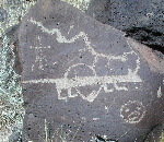
17th century, crucifixes and sheep brands were made by Hispanic people
(see right picture below). Anglo explorers of the late 18th century
chiseled names into the boulders. The vast majority of the petroglyphs,
though, were created four to seven centuries ago by the Rio Grande's
Puebloe people. After having lunch at Country Market (Flying J) we headed
to Acoma Sky City which was built ca. 1150 A.D. by Pueblo Indians on top
of a massive sandstone mesa which rises 110 m above the valley and approx.
2,100 m above sea level. Acomans claim that their village is the oldedst,
continuously inhabied city in the U.S. Today, less that 50 Acomans live in
the Sky City year-round and the remaining residents live in nearby
villages. Only on feast days do all the Acomans gather on the mesatop. To
visit the pueblo you have to sign up for a guided walking tour. We went up
with the shuttle bus but down we walked the traditional stairs trail on
steep slopes.
03.10.00 Fahrt zum Petroglyph National Monument, wo
uns dann ein 5 km langer Spaziergang im Piedras Marcadas Canyon zu den
Petroglyphen (eingeritzten Zeichnungen). Die frühesten Felsbildern,
abstrakte Linienmuster, wurden vor 2.000 bis 3.000 Jahre von archaischen Völker
erstellt. Ab dem 17.Jh. sind Kruzifixe und Schafbrandmarkierungen von den
spanischen Besetzer (siehe Foto unten rechts)dazugekommen. Englische
Siedler des späten 18.Jh. haben ihre Namen in den Felsen eingeritzt.
Die größte Mehrheit der Bilder wird auf 400 bis 700 Jahre alt
geschätzt und wurde von den Rio Grande Völkern erstellt. Nach
einem sehr guten Mittagessen im Country Market an einem Flying J-Autohof
sind wir zu Acoma Sky City gefahren. Diese Stadt wurde ca. 1150 von
Pueblo-Indianer auf einem Felsplateau 110 m über das Tal und ca. 2100
m ü.M. gebaut. Die Acoma-Indianer behaupten, dass ihr Dorf die älteste,
ständig bewohnte Stadt in USA ist. Heutzutage leben weniger als 50
Acoma-Indianer das ganze Jahr über in der "Himmelstadt",
die restlichen Bewohner haben sich in der Umgebung angesiedelt. Nur an
Festtagen treffen sich alle Acoma-Indianer oben auf dem Felsplateau. Um
das Dorf zu besichtigen - da wohnen nämlich immer noch Leute - muss
man an einer Tour teilnehmen. Wir sind mit dem Shuttle Bus hochgefahren
aber runter zu Fuß über den traditionellen, alten Weg mit ganz
steilen Stufen gegangen.
 . . . . .
  . . . . .
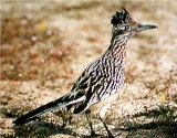
Petroglyph National Monument, New Mexico: Apart from seeing thousands
of petroglyphs, we saw for the first time a roadrunner on the wild! /
Ausser tausende von eingeritzten Zeichnungen, 3.000 Jahre alt, haben im
Petroglyph National Monument einen "ándale-ándale"-Wüstenläufer-Vogel
auf freier Laufbahn gesehen - Hilfe! Wie hießt
dieser Vogel auf Deutsch?
mailto:biebesheimer@compuserve.com
 . . . . .
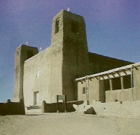
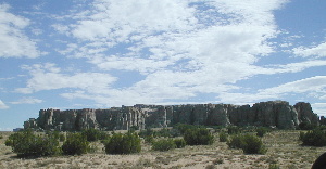
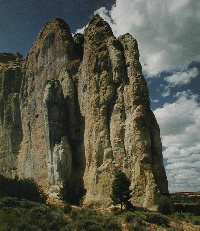
Acoma Sky City, New Mexico, lies on top of this mesa and is the oldest
continuosly inhabited Puebloan town in the US; the San Esteban Church and
Mission was built by the Spanish from 1629 to 1640./ Acoma Sky City,
New Mexico, liegt oben auf diesem Plateau und ist die älteste
ununterbrochen bewohnte Pueblo-Stadt in the Staaten; die San
Esteban-Kirche und die Mission wurden von den Spaniern von 1629 bis 1640
gebaut.
04.10.00 Hike from our excellent (free of
charge) campground at the Narrows to La Ventana Natural Arch (12 km, 3,5
hours). In all this area lava that poured out of McCarty's Cone
established a new land surface 2,000 to 3,000 years ago. In the afternoon
we relaxed and in the evening we had fantastic steaks on Volker's biggest
campfire!
04.10.00 Wanderung von unserem ausgezeichneten (und
kostenlosen) Stellplatz bei den Narrows zu La Ventana Natürlicher
Bogen (12 km, 3,5 Stunden). In der ganzen Gegend hat Lava, die vom
McCarty's Vulkan vor 2.000 bis 3.000 Jahren ausgespuckt wurde, eine neue
Landschaft gebildet. Nachmittags haben wir ohne große Aktivitäten
verbracht und abends haben wir tolle Steaks gegessen, die Volker auf
seinem bis jetzt größten Lagerfeuer gegrillt hat!
 . . . . .
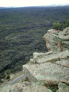
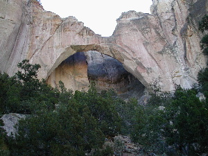
El Malpaís National Monument: From our parking we hit the "Narrows
Trail", walked up to the 150 m high mesa, then went all the way to La
Ventana Natural Arch (right) viewing down upon lava flow that almost
reached the base of the sandstone cliffs (left). / Von unserem
Stellplatz sind wir dem Wanderweg hoch auf das 150 m hohe Felsplateau bis
zum natürlichen Bogen "La Ventana" gefolgt (rechts). Von
oben sah man sehr schön die Lava die unten fast bis zu den Felsen
(links) geht - deshalb nennt sich diese Strecke "Narrows" ('enge
Stelle').
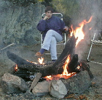 Volker's biggest campfire / Volkers größtes Lagerfeuer.
05.10.00 Volker hat the idea of hitting the
Zuni-Acoma Trail which begins on the east side on Highway 117 (from where
we were) and ends on Highway 53 (where we wanted to go). I would make the
the big loop on the road and wait for him 4 hours after his departure.
This would give me time to make some shopping in Grants. I tell you I
could have spent even more time there... We then drove to El Morro
National Monument where we just made it to the Visitor Center and the
campground.
05.10.00 Volker hatte die Idee, den Zuni-Acoma Weg,
der auf der Ostseite an der Highway 117 beginnt (wo wir uns gerade
befanden) und an der Highway 53 endet (wo wir hinwollten) zu begehen. Ich
würde dann den großen Bogen mit dem Wohni fahren und vier
Stunden später auf der anderen Seite stehen. Das würde mir Zeit
zum Einkaufen in Grants geben. Stimmt, aber ich hätte noch mehr Zeit
gebrauchen können... Dann sind wir zum El Morro National Monument
gefahren, wo wir es gerade noch geschafft haben, zum Besucherzentrum zu
gehen und uns auf den Campingplatz hinzustellen.
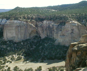
 La Ventana Natural Arch, El Malpaís National Monument, New
Mexico, USA
La Ventana Natural Arch, El Malpaís National Monument, New
Mexico, USA
 . . . . .
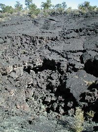
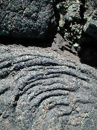
El Malpaís National Monument, New Mexico. The Zuni-Acoma Trail
crosses four lava flows and it is a strenuous hike over rugged terrain. /
Der Zuni-Acoma Weg überquert vier Arten von Lavaflüssen und
ist eine anstrengende Wanderung über sehr unregelmäßiger
Oberfläche.
06.10.00 El Morro: On a main east-west trail,
dating from antiquity, rises a great sandstone promontory with a pool of
water at its base. Over the centuries those who traveled this trail
stopped to camp at the shaded oasis under the cliffs and left carved
evidence of their passage -symbols, names, dates, and fragments of their
stories. The first ones to do so where the Ancestral Puebloans, then the
Spaniards, and from 1849 to 1881 the Americans. We walked the Inscription
Rock Trail and then continued our hike on up over the mesa top, past the
ruins of Atsina and the box canyon. In the afternoon drive to Zuni Pueblo
where I was delighted by the fine inlay jewelry. Overnight parking at the
Arizona Welcome Center.
06.10.00 El Morro: An einem Hauptweg von Osten nach
Westen, dass es seit Urzeiten gibt, erhebt sich ein Sandsteinfelsen mit
einem kleinem See an seinem Fuß. Über die Jahrhunderte haben
die Leuten, die diesem Weg gefolgt sind, hier einen Übernachtungsstop
an der schattigen Oasis unter den Felsen und haben einen schriftlichen
Beleg Ihres Besuches - Symbole, Namen, Daten und Teile Ihrer Geschichte -
hinterlassen. Die Anazasis (die Vorfahren der Zuni) waren die ersten, dann
die Spanier und zuletzt die Amerikaner von 1949 bis 1881. Wir sind den Weg
entlang der Inschriften am El Morro und danach sind wir hoch auf die Mesa.
Dort haben wir die Ruinen der früheren Indianerstadt "Atsina"
sowie den Boxcanyon gesehen. Nachmittags Fahrt zum Zuni Pueblo, wo ich
wieder schwer begeistert war mit dem Zuni-Schmuck. Übernachtung am
Parking des Arizona Welcome Center.
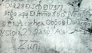
El Morro National Monument, New Mexico.The spanish inscription says:
'The 28th day of September of 1737, arrived here the illustrious Senor Don
Martin de Elizacochea, Bishop of Durango, and the day following, went on
to Zuni'. / Die spanische Inschrift besagt: 'Am 28. Tag im September
1717 ist der hochgeehrte Senor Don Martin der Elizacochea, Bischoff von
Durange, hier angekommen und am nächsten Tag ist er weiter nach
Zuni.'
back to homepage / zurück
zur Homepage
to previous page / zur
vorigen Seite . . . . to next page /
zur nächsten Seite
to top of page / zum Seitenanfang